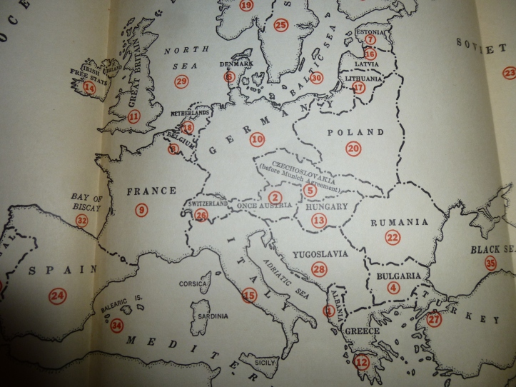
Recently, I picked up an updated copy of “Inside Europe” by John Gunther. It’s a book written shortly before the outbreak of World War II which details the political situation in Europe. In the front cover is a map of Europe at the time. My copy is the updated 1939 version. At the time, the map was changing quite a bit. World War II would break out within the year, but so far no violent German annexations had occurred.
Two things of interest in this map are the non-wartime annexations that are acknowledged, but not depicted. Firstly: Czechoslovakia. Czechoslovakia at this point has been split into parts. Germany had taken control of Sudetenland in northwest Czechoslovakia as a result of the Munich agreement, and other parts of Czechoslovakia had been claimed by Poland and Hungary. In this map however, Czechoslovakia is shown as it was before splitting, and labeled as “Czechoslovakia (Before Munich Agreement)”. Secondly: Austria. Austria had been wholly annexed by Germany by this point in what is known as the Anschluss and was renamed “Ostmark“. On this map, Austria is depicted (as with Czechoslovakia) with its previous borders and labeled as “Once Austria”. At first I thought this was extremely curious. I thought perhaps it was temporarily the accepted name of the country (as if people talked of “Once Austria”), but it would make much more sense that it would be meant to convey that that country was once Austria (as in, “Formerly Austria”).
My guess as to the reason for these depictions and labels is that this updated version of the book didn’t extend to an updated map. They could update labels easily, but a redesign for the new borders would require more work than they were willing to do. It’s not just laziness however, there’s also some benefit to not changing borders. The border changes had happened recently enough that there might have been some uncertainty not only to the precise borders, but the names of what to call them. In German, Austria went from the country of Österreich to the state of Ostmark. Was there a new name for it in English? In Czechoslovakia, multiple regions had been carved from it by Germany, Poland, and Hungary. Perhaps the precise borders weren’t yet known (or agreed upon)? It’s probably better to use known information even if it is outdated than to guess about the newest borders, names, etc. and get it wrong.
Another thing to note about Austria and Czechoslovakia being depicted with their former borders: It’s also a piece of persuasive cartography (whether deliberate or not). Showing the countries as their whole and independent selves gives the impression that the German annexations aren’t valid––that although land has been claimed no borders have changed. I’m absolutely not sure if that was the intent, but it’s certainly possible. It’s not hard to believe that the most-likely-American cartographer would be biased against Nazi Germany.