
My masters thesis project was to create a topographic map of Mt. Kilimanjaro. Part of that project was to look at other maps of the area and compare features. Conflicting features would then be checked either with satellite imagery or field truthing. I was lucky enough to be able to go to Tanzania to live on Mt. Kilimanjaro for a couple months, so I was able to do some field work. Roads were the main features (but certainly not the only) that I was doing field work for. The majority of my road information came from 30-50 years ago. Lots of roads have been created since then, and many roads’ quality has changed (e.g. dirt trail widened and graveled, dirt road paved, etc.) so I really needed some more recent data.
One day when we were driving around the savannah in what would be the southwestern area of my map, we went on a completely new road (not on the maps, looked like nice new gravel). Essentially, we just had to drive on the road to get the gps track, so I was checking the surrounding features like the buildings, swampy areas, creek beds, etc. It hadn’t rained much recently so the swampy areas weren’t very wet, but they were still obviously identifiable. Whereas the ‘non-swampy’ areas were light reddish brown soil with mostly brown vegetation (if any at all), the swampy areas were depressed a bit (maybe a meter or so), had much darker soil, and short green vegetation. The green vegetation was far too small to identify (it seemed to be something only barely sprouting), but when the alternative is fields of brown soil with the occasional brown vegetation, you notice the green even if it is just a small trace.
So as we drove down this gravel road, I was looking at the green sunken areas to corroborate the seasonal swamp areas on the map. All of them were looking good until we got to one large seasonal swamp shown on the map. I really couldn’t see any sign of a swamp in real life. The field wasn’t sunken like the seasonal swamps, it was bright brown soil, with no green sprouts whatsoever. After a few seconds of driving, I did see a small patch of land that was indeed sunken, dark, and with a trace of green, and also contained a small water hole as shown on the map. So there’s indeed a portion of land recognizable as swamp, but certainly not the entirety of what was shown on the map. Perhaps the swamp used to be larger when the map was made (50+ years ago), but has shrunk over the years? I made a note of where I was and which portions were suspect, and I would take a look at historical satellite imagery later.
Later, after looking at satellite/aerial imagery, I saw that there was indeed only a small patch of swampy area, the rest didn’t seem to exist at any point in time (or at least it wasn’t evident by the historical imagery). How strange. Then I started to really look at that suspect patch of seasonal swamp shown on the map. I noticed a peculiar resemblance of the non-existent part of the swamp to a flipper. Then I realized that the entire patch is shaped a bit like a whale with a tail and flipper. Furthermore, the waterhole is suspiciously close to where an eye would be on this whale, and a road going out of the patch of swamp is precisely where you would expect a blowhole to spray water and air. All of this was just too coincidental to be in fact coincidental. I fully believe that I found a cartographic trap.
-
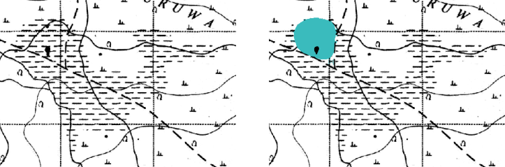
Left: Seasonal swamp depicted in the topographic map. Right: The swamp and waterhole in reality
Cartographic copyright traps are non-existent features that cartographers put on a map so as to “trap” someone who makes a direct copy of their map. Often they take the form of fictional towns, known as “phantom settlements” or “paper towns”. Some examples include the Ohio towns of Beatosu and Goblu shown in a Michigan state map (The names are derived from “Beat OSU” [the rival Ohio State University] and “Go Blue” [a University of Michigan sports cheer]) and Agloe, New York, which humorously started as a cartographic trap on an Esso map of New York, but then became a bit more real when someone started the “Agloe General Store” where the map showed the town of Agloe to be.
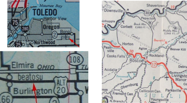
- Some phantom settlements: Beatosu, Goblu, and Agloe
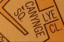
Other common cartographic traps are “trap streets”, also known as “paper streets”, such as the non-existent Lye Close as shown on a Bristol A-Z map (Hehe, get it? lye/lie?). Sometimes they are non-existent streets, but sometimes they’re simply unnamed streets that are given a name on a map ––no other map should have that name there unless it’s been copied.
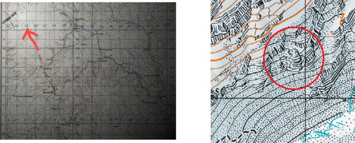
Another type of trap is more of a hidden image, or easter egg. If you recognize it for what it is, it’s probably obvious that it can’t be real. Some examples of that include an elephant appearing on an Ordnance Survey map of the Gold Coast, and a marmot appearing on the Aletsch Glacier on a Swisstopo map.
So, back to my savannah whale. There’s no phantom settlement or trap street, but it certainly seems like a hidden image. There’s a possibility that any resemblance to any creature is all coincidence and the original surveyors actually did run into a larger, interestingly shaped swamp. Though I think it quite clearly looks like a whale. It could have been added on a lark, but it also could have been added as a trap feature. I think it’s cool that I found it; who knows if anybody has found it before? What do you think? Does it look like a purposeful trap to you?


[…] for “Royal Company Is.” These islands are completely made up. It’s not a Cartographic Trap, but a phantom island. At some point in time, a mariner noted down in his log book that a claim […]
LikeLike