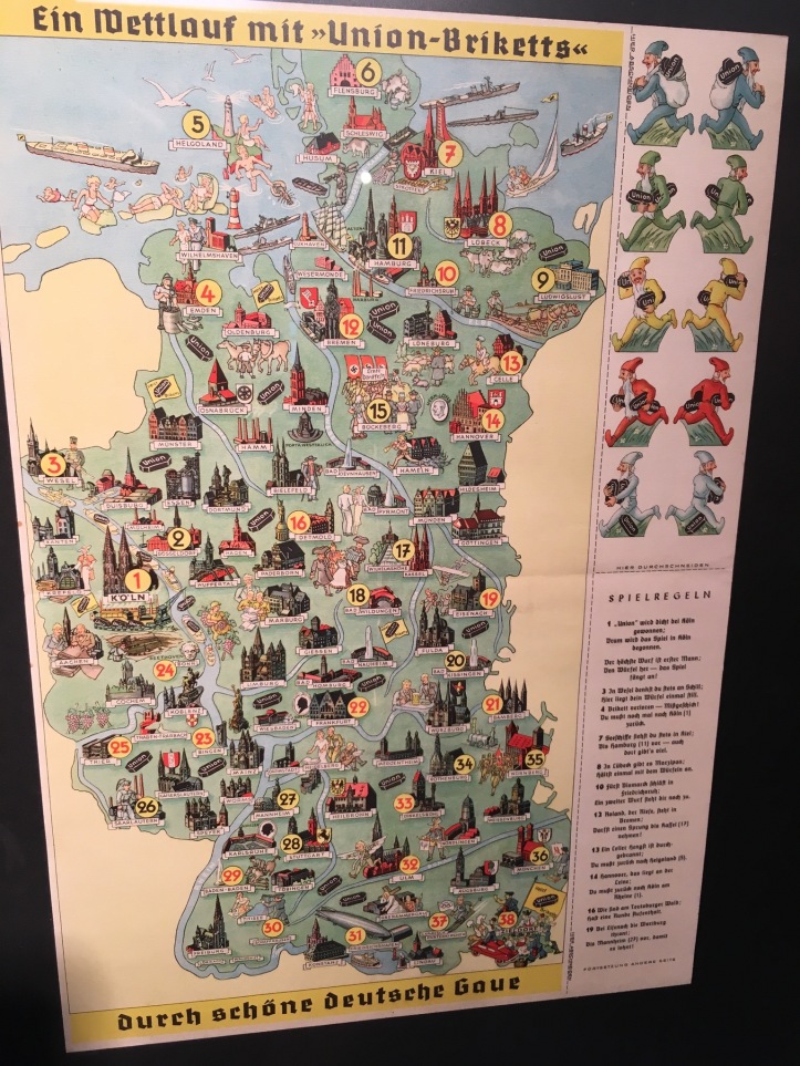
I recently visited the Schopfheimer Stadtmuseum (the city museum of the town I’m living in). One the ground floor, they have an exhibition on games on display. They have dozens of board games and card games from over the last hundred years. One of the game boards at the museum was published in the 1930s by a coal company in Western Germany. It’s entitled “Ein Wettlauf mit ‘Union-Briketts’ durch schöne deutsche Gaue” (A race with Union briquettes through beautiful German regions).
80+ German towns and cities are labeled and they include a small picture of something notable about the city, sometimes a famous building or statue such as the cathedral in Köln [Cologne] or the statue of Roland in Bremen, sometimes a small scene with characters depicting something notable about the city or area such as someone peering into the archaeological pits of the Neander valley (Neandertal), Nazis in Nürnberg [Nuremberg] where large Nazi rallies were held, or a skier and olympic flag in the ski town of Garmisch-Partenkirchen (the 1936 Winter Olympics were held there). In among these small buildings, statues, and scenes are plenty of small black oblong faceted bricks with the name of union on them (especially in Köln, where they seem to be coming from)––these surely must be be the coal briquettes (though it would be obvious at the time to those playing this game, the only coal briquette I’m familiar with are the rounded square ones used in a barbecue grill. I can only assume that the union briquettes must have been these oblong, faceted shapes stamped with the union name). Some of the scenes are either unrecognizeable, or else I don’t understand the reference. For instance, in Würzburg is a scene where someone is seemingly being served a beer. I’m not entirely sure what makes it especially noteworthy for a beer to be served in Würzburg (it’s not exactly uncommon in Germany). There’s almost certainly some reference that is lost on me.
In the Southwest is a town named “Saarlautern”. It’s interesting for a couple reasons. Saarlautern doesn’t exist today. I had never heard of Saarlautern before, but assumed that it was simply a former name of Saarbrücken. After looking it up, it’s actually the town now known as Saarlouis. Apparently its name was changed because it was a bit too French. Under Nazi Germany, any towns with non-German names were Germanized, so Saarlouis became Saarlautern (it very quickly returned to “Saarlouis” after World War II). Saarlouis is much smaller than Saarbrücken today (populations of around 35,000 vs. 175,000+). It’s strange that they would have chosen to map Saarlautern instead of the much larger Saarbrücken (which was presumably much larger in the 1930s as well). One possible clue is given by the scene depicted in Saarlautern; a factory and what seems to be a miner. Perhaps they wanted to showcase a mining town instead of Saarbrücken, the entire game is about coal after all.
At first glance, it would seem as if though West Germany has been mapped. This map coming from the 1930s, West Germany didn’t yet exist, so that’s a bit odd. Looking a bit closer, there are portions of the former (then future) DDR (East Germany) that are mapped as well as a chunk of the BRD (West Germany) that hasn’t been mapped (especially in Bayern [Bavaria]). So, why this division? Well, it turns out there were two large coal companies in Germany at the time, one which sold their coal in eastern Germany and one in western Germany. This board game shows only the area where Union was the main coal producer and seller. It’s interesting that although a divided Germany was still in the future, at least coal companies, Germany was still thought of in terms of east and west.